Weekly Weather Forecast
Met Service
19 January 2025, 7:33 PM

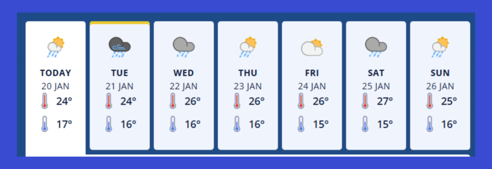
Warkworth / Rodney Region
Monday 20th January - Partly cloudy. Scattered rain, mainly in the morning and north of the Harbour Bridge. Easterlies, strong in exposed places.
Tuesday 21st Jan - Rain with heavy falls, easing to a few showers in the afternoon. Gale easterlies possible in exposed places, easing in the afternoon.
Heavy Rain Watch
- Period: 12hrs from 4am - 4pm Tue, 21 Jan
- Area: Auckland and Great Barrier Island
- Forecast: Periods of heavy rain, and amounts may approach warning criteria. Thunderstorms possible. Moderate chance of upgrading to a Warning.
Strong Wind Watch
- Period: 6hrs from 5am - 11am Tue, 21 Jan
- Area: Auckland, Great Barrier Island and Coromandel Peninsula
- Forecast: Easterly winds may approach severe gale in exposed places. Moderate chance of upgrading to a Warning.
Wednesday 22nd Jan - A few showers. Southerlies, easing.
Thursday 23rd Jan - A few showers. Southwesterlies, becoming fresh.
Friday 24th Jan - Partly cloudy. Westerlies, easing.
Saturday 25th Jan - Showers. Northwesterlies.
Sunday 26th Jan - A few showers with southwesterlies.

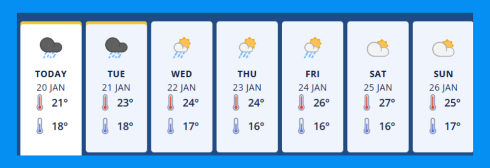
Mangawhai / Northland Region
Monday 20th January - Rain, possibly heavy from evening. Fresh easterlies.
Heavy Rain Watch
Period: 14hrs from 10pm Mon, 20 Jan - noon Tue, 21 Jan
Area: Northland
Forecast: Periods of heavy rain, and amounts may approach warning criteria. Thunderstorms and localised downpours are possible. It is likely that this Watch will be upgraded to an Orange Warning on Monday morning. Note: Periods of heavy rain are expected north of Kaikohe during Monday morning and afternoon, especially in the east, but widespread accumulations are not expected to approach warning criteria. High chance of upgrading to a Warning.
Impact: Streams and rivers may rise rapidly. Surface flooding, slips, and difficult driving conditions possible.
Action: Clear your drains and gutters to prepare for heavy rain. Avoid low-lying areas and drive cautiously. Preparedness advice.
Tuesday 21st Jan - Rain with heavy falls, clearing to fine in the afternoon. Strong southeasterlies, turning lighter northerly in the morning.
Heavy Rain Watch
- Period: 14hrs from 10pm Mon, 20 Jan - noon Tue, 21 Jan
- See above for details
Strong Wind Watch
- Period: 7hrs from 1am - 8am Tue, 21 Jan
- Area: Northland
- Forecast: Easterly winds may approach severe gale in exposed places. Moderate chance of upgrading to a Warning.
Wednesday 22nd Jan - Partly cloudy, with a few showers developing in the morning. Southerlies developing.
Thursday 23rd Jan - A few showers developing. Southwesterlies, becoming fresh.
Friday 24th Jan - A few showers. Southwesterlies.
Saturday 25th Jan - Partly cloudy. Northwesterlies.
Sunday 26th Jan - Partly cloudy with southwesterlies.


