Northland Corridor Dec '25 Update - ROUTE MAPS 🛣

Waka Kotahi NZ Transport Agency
10 December 2025, 1:00 AM
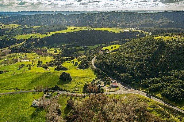 View looking north at the intersection of SH1 and SH12, approaching the Brynderwyn Hills
Project update - December 2025
Tēnā koe and welcome to the Northland Corridor newsletter.
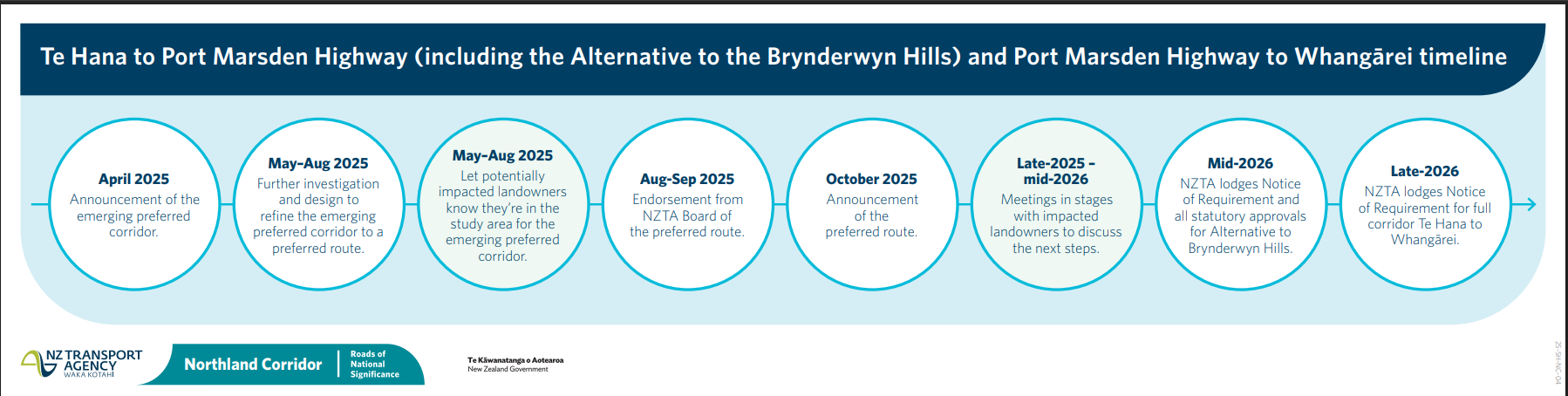
We have had a busy month following the NZTA Board’s endorsement of the Northland Corridor Investment Case and the preferred route between Te Hana and Whangārei earlier this year. All landowners within the preferred route should now have recieved their letter communicating this, and we have started to have individual meetings with landowners. Due to the 75 km length of the corridor, individual landowner engagement is occurring in a staged approach, beginning with potentially affected landowners in the Alternative to the Brynderwyns Hills section.
Landowners between Waipu and Whangārei will be contacted again early next year with further information to book in their individual meetings with the project team.
These meetings are an opportunity to discuss indicative land impact plans for individual properties, geotechnical and environmental assessments, and outline the next steps toward route protection. Within these sessions landowners will be invited to discuss their individual requirements and share valuable insights with the project team.
We understand that waiting for a meeting may be frustrating, so we want to thank landowners for their patience while we work through this process. There is some more information for landowners below.
Now that all landowners have received their letters, we are sharing overview maps of each section of the preferred route on our website. These are called ‘long plot maps’. Long plot map shows the preferred route over a large area. It helps show how the project fits into the wider landscape. Read on for more information on these.
We have also been busy undertaking geotechnical and environmental investigations along the preferred route. All this important data helps us us to refine the corridor further, prior to lodging Notices of Requirement (NoR) in 2026. There is more information on what we are doing in this space below as well as a video showing some of our geotechnical investigations in the Alternative to the Brynderwyn Hills section and a spotlight on bat and lizard monitoring.
Procurement for Ara Tūhono – Warkworth to Te Hana is also progressing well, with the evaluation phase expected to start before the end of this year and continue into the first quarter of 2026. Following a negotiation period, the contract is expected is expected to be awarded at the end of July 2026.
FAQS
What are the next milestones for the project?
Once we have completed landowner engagement and the refinement of the preferred route, we will move into the route protection phase for the whole corridor. This means securing the land we need by legal designation through the Notice of Requirement (NoR) process. Route protection provides certainty for landowners and helps with future planning.
To address the critical resilience issues to the Brynderwyn Hills, we plan to lodge the NoR and resource consent applications for the Alternative to the Brynderwyn Hills section of the project first, and we expect to do this by mid-2026. NoR lodgement for the remaining sections between Te Hana and Whangārei is expected to occur in late 2026.
When do you expect to be able to confirm property impacts for landowners?
We will confirm property impacts with individual landowners about a month prior to lodging the NoR for each section.
Are there any more community info sessions coming up?
Our priority at the moment is to meet with individual landowners. The volume of meetings currently being held means we won’t be having any more community info sessions until the current round of engagement with landowners is completed mid-2026. You can always reach out to our team via email or phone if you have questions. Email [email protected] or phone us on 0800 927 293.
More information for landowners is available here: SH1 Northland Corridor information sheet for landowners – October 2025
Who considers the project’s NoR and consent applications?
The project plans to use the Fast-track Approvals Act (FTAA). Under the FTAA, the NoR is lodged with the Environmental Protection Agency (EPA), who appoints an independent expert panel to consider and make a formal decision on the application. This may take 6 to 9 months. If you are an affected party, you may receive a request from the EPA to provide comment.
Why does the preferred route go to the west between Finlayson Brook Road and Port Marsden Highway?
The location of the preferred route reflects resilience, safety, and value for money tradeoffs, and environmental, cultural and geotechnical considerations, particularly avoiding known flooding risks and geotechnical challenges between the base of the Brynderwyn Hills and Whangārei. It also reflects the importance of a direct connect into Waipu and allows flexibility to respond to the planned growth for Ruakākā, avoids impacts to Ruakākā School, while maximising efficiency for movements to the Port.
For the preferred route between Finlayson Brook Road and Port Marsden Highway, a new road to the west of the existing state highway 1 was selected as it is the lowest cost option and has the best cut/fill balance to enable efficient construction.
Widening of the existing state highway 1 was discounted due to the complexity of retaining access to existing SH1 properties. This would result in higher cost, constructability issues and ultimately wider final footprint due to requirement for service lanes. In addition, it would be much more disruptive during construction to the travelling public if the existing highway was widened.
Preferred Route Te Hana to Whangārei long plot maps
Now that all landowner letters have been sent out long plot maps of the preferred route corridor are now available on our website. A long plot map shows the preferred route over a large area. It helps show how the project fits into the wider landscape. They are indicative only, and do not show the final area or where the new road will go.
What do the yellow dotted lines mean?
They show the boundary of the preferred route, not where the final road will go.
Why does the corridor look so wide in places?
There are still many different places the final route may go within the preferred route. We are at the route protection stage, which means we are working towards protecting the land for future planning to build the road. The area we will protect needs to give room for further environmental and geotechnical investigations, innovation in future design, and allow for the extra area we will need during construction of the road, for things such as lay down areas, access, stormwater systems and other required mitigation areas.
Is this the final area you will be applying for route protection for?
No. We are currently undertaking geotechnical and environmental investigations as well as design development and having individual conversations with landowners to help us refine the corridor further. We expect to lodge the Notice of Requirements (NoR) to route protect the area for the Alternative to the Brynderwyn Hills by mid-2026 and for the remaining sections of the corridor by late 2026. We will share the updated maps when we lodge the NoR.
Links to long plot maps
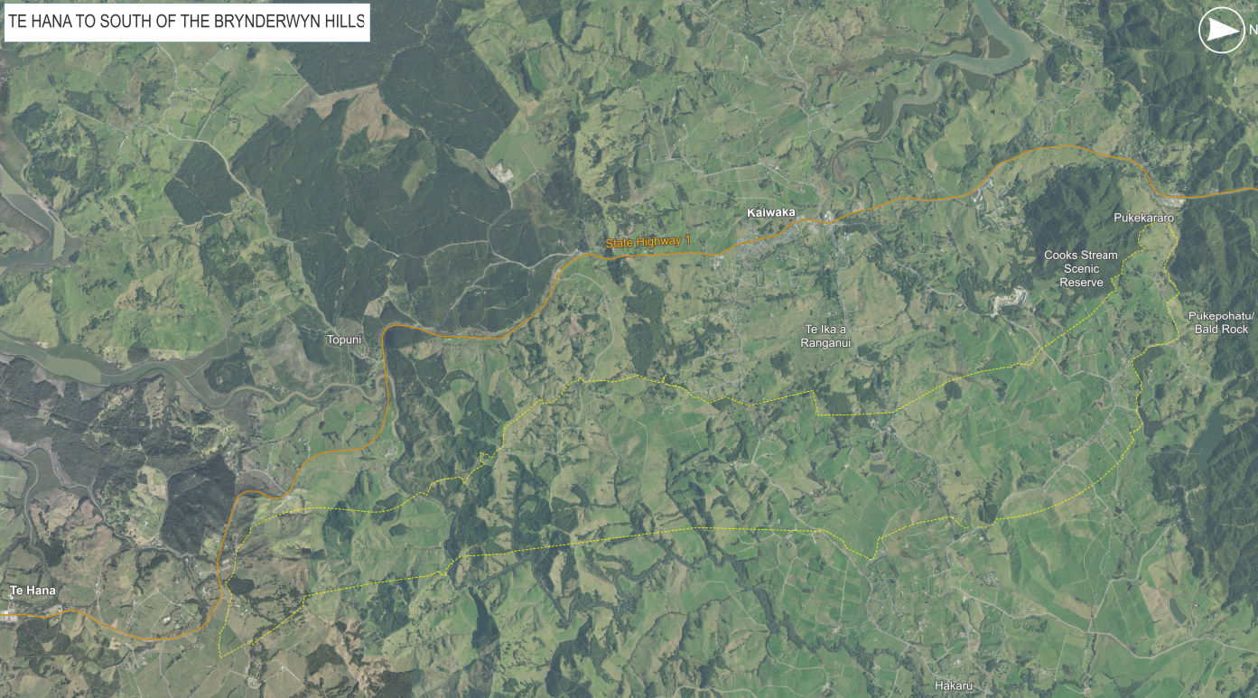
Te Hana to South of the Brynderwyn Hills preferred route map
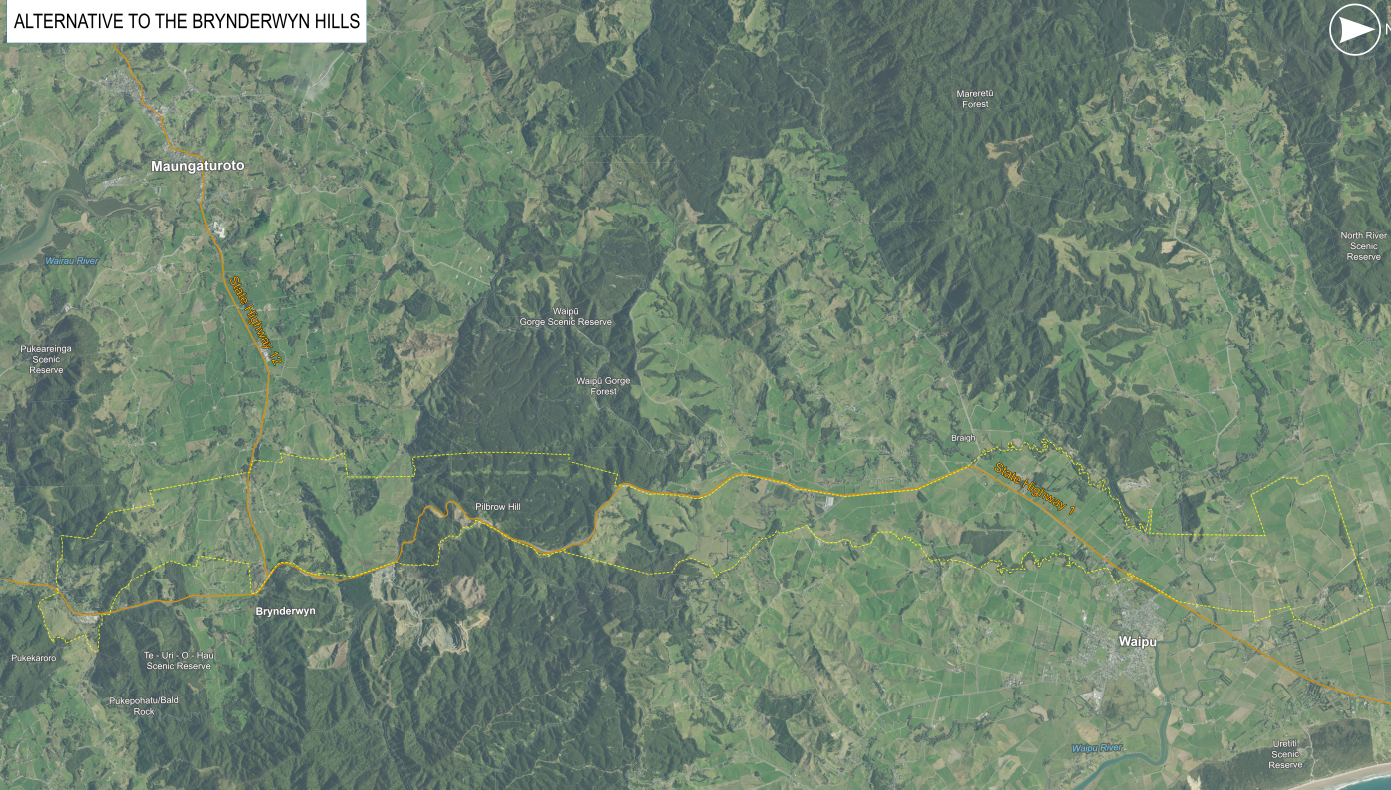
Alternative to Brynderwyn Hills preferred route map
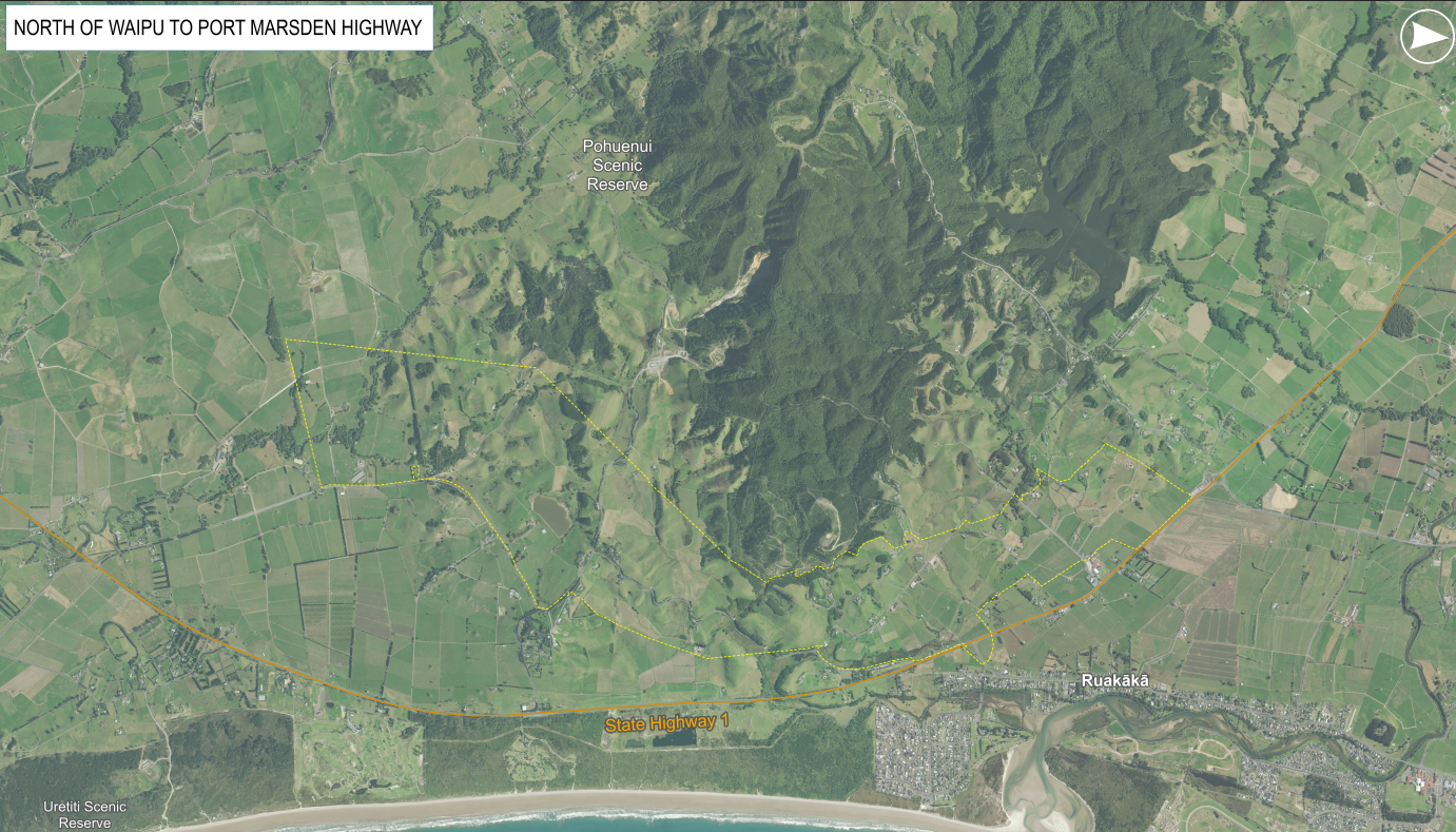
North of Waipu to Port Marsden Highway preferred route map
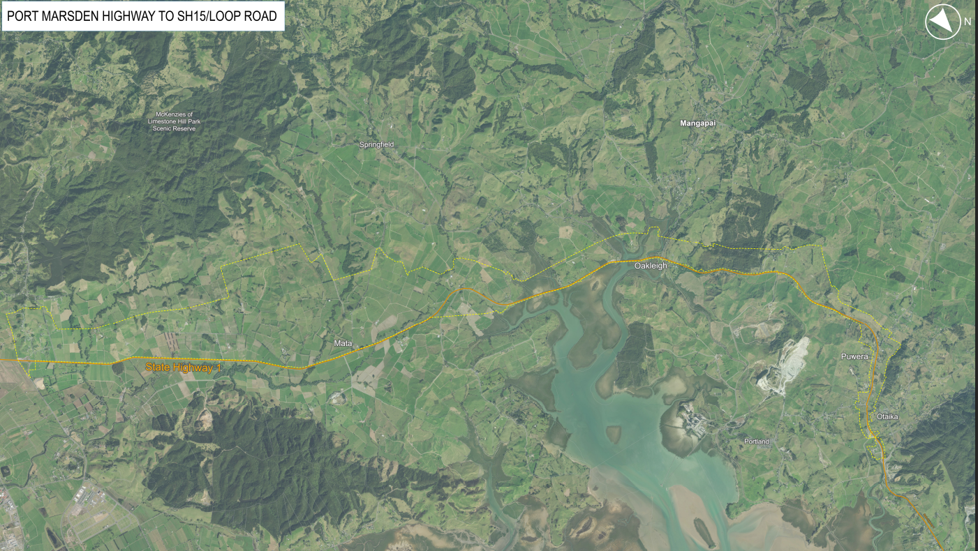
Port Marsden Highway to SH15/Loop Road preferred route map
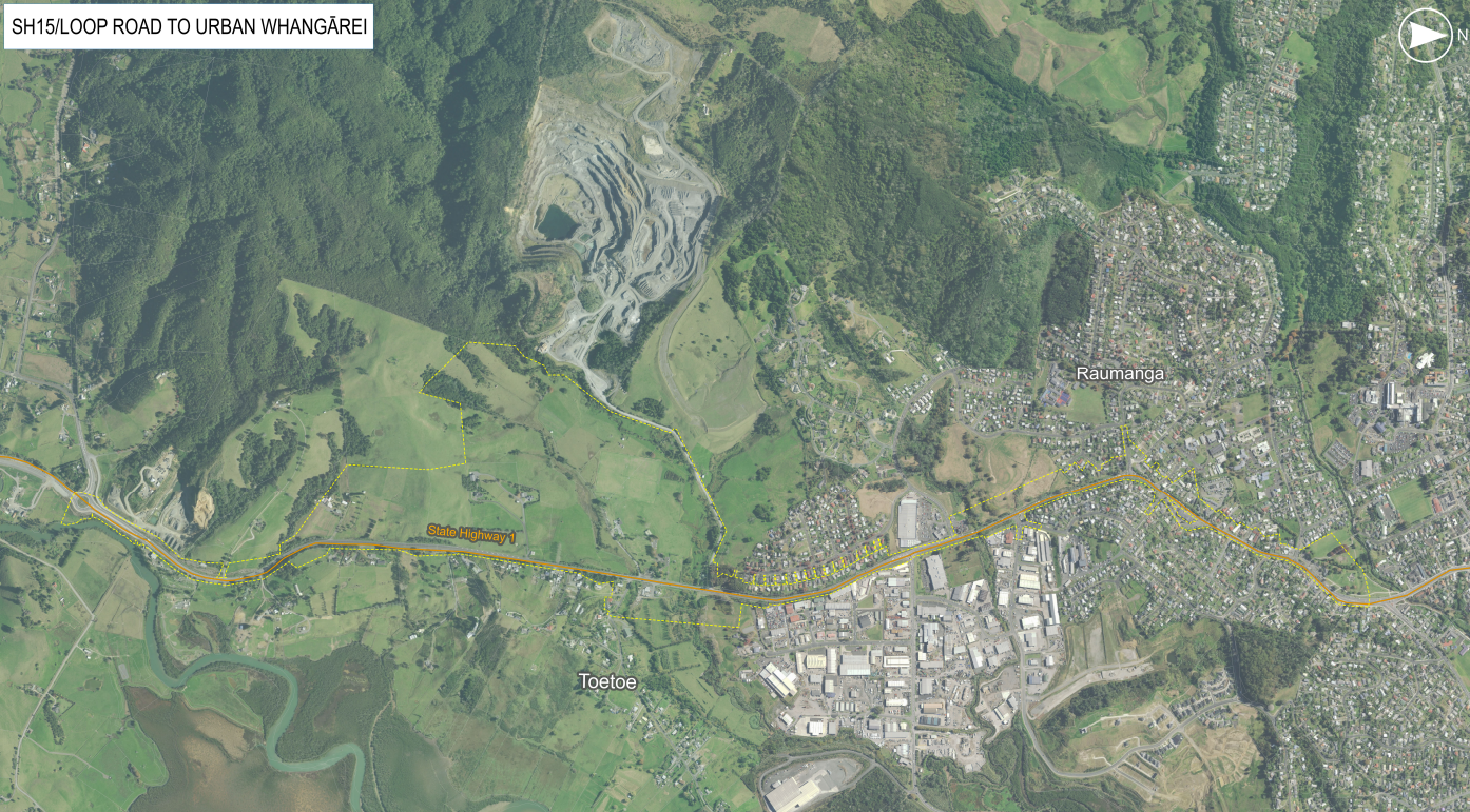
SH15/Loop Road to urban Whangārei preferred route map
Reminder for landowners to register your contact details
So that we can contact landowners as quickly and efficiently as possible, we want to make sure we have all the contact details of landowners who may be potentially affected.
If you have received a letter from us advising that your property is within the preferred route, please register your contact details. Instructions on how to register your contact details are provided in your letter.
It is quick and easy to register via the online form and only takes about one minute.
Alternatively, please email us at [email protected] or phone us on 0800 927 293 to register your contact details.
Environmental and Geotechnical Investigations
Te Hana to Port Marsden Highway and Port Marsden Highway to Whangārei investigations
A range of site investigations are needed to help us better understand how the new road could be constructed, what sort of impacts the new road may cause to the local environment, and how any potential impacts can be mitigated. The information gathered through site investigations provides important information to ensure the size of the final preferred route (or footprint of the project) is only what will be required for the future construction and operation of the new road.
In the video you can see some of the geotechnical investigations underway in the Alternative the Brynderwyn Hills section.
Environmental assessment: spotlight on bat and lizard monitoring
A number of environmental assessments are underway to help us better understand the ecology (plants and animals) living in and around the project area, such as bats and lizards.
The ecology team have been carrying out bat and lizard monitoring at various locations along the preferred route in the Brynderwyn Hills Alternative section of the project.
Monitoring for bats involves the placement of an acoustic bat recorder, preferably along the edge trees and potentially hanging from a tree branch 2-3m high. The acoustic bat recorder is a small, self-powered device that records ultrasounds that bats use to echolocate at night. The recorder is left on site for approximately 6 weeks before they are collected. The recorders are placed along the corridor to find out not only where bats might be living, but where they travel to and from.
Lizard monitoring involves the placement of a small tile that is placed near rough grass or bushy edges on the ground and is checked a number of times over a 6-week period.
Information gathered during the assessments will be used to help us plan how to manage or avoid any impacts and effects.
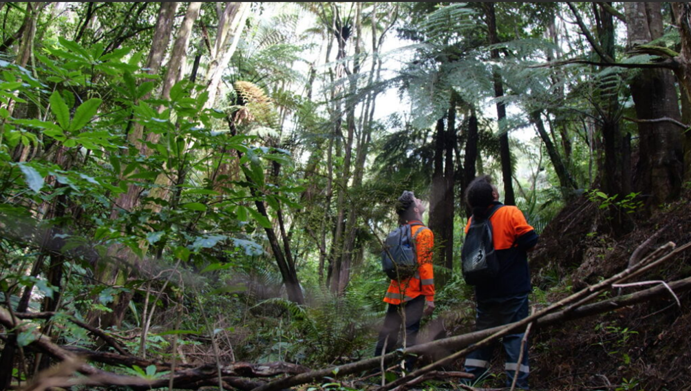
Members of the ecology team looking for the best location to place bat monitors.
Ara Tūhono – Warkworth to Te Hana
Procurement for the project as a Public Private Partnership (PPP) is progressing well. NZTA will be moving into the negotiation stage after the evaluation of proposals is complete at the end of March 2026, with the contract expected to be awarded by end of July 2026. The successful PPP consortia is expected to start detailed design and early construction works by the end of next year.
For more information on the Northland Corridor project, contact us at [email protected]


